


By Anil Anwar | Contributor, Asia –
Rahim Yar Khan, located in Pakistan’s Punjab Province, serves as the capital of both Rahim Yar Khan District and Rahim Yar Khan Tehsil. Positioned in the southern part of the province, the city is connected to the rest of Pakistan by air travel, rail, and a modern road network, despite its considerable distance from major urban centers such as Karachi and Lahore.
The district is bordered by Muzaffargarh District to the north, Bahawalpur District to the east, Jaisalmer in India, Ghotki District of Sindh Province to the south, and Rajanpur District to the west. Administratively, the city is divided into nine Union Councils.
Geographically, the district consists of three distinct physical regions: the riverside area, the canal-irrigated area, and the desert region known as Cholistan. The riverside area lies along the southern side of the Indus River and primarily falls within the riverbed. South of this region is the canal-irrigated tract, separated by the Minchan Bund, with elevations ranging from approximately 150 to 200 meters above sea level. Further south lies Cholistan, extending toward the Indo-Pak border.
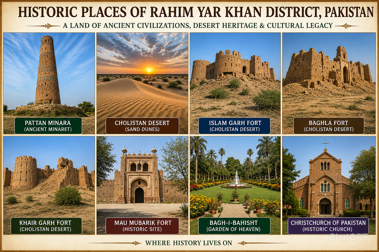
The Cholistan Desert is characterized by a succession of sand dunes, some reaching heights of approximately 150 meters. The landscape supports vegetation commonly associated with sandy terrain and remains one of the district’s most distinctive natural features.
Rahim Yar Khan experiences a hot, dry summer and a cold, dry winter. Summer typically extends from April through October, while winter lasts from November through March. The transitional months of March and November are generally considered pleasant. Dust storms are common during the summer months, and the district receives an average annual rainfall of approximately 100 millimeters.
The city can be reached through Pakistan’s National Highway N-5 and is home to Sheikh Zayed International Airport. The airport is currently undergoing a feasibility study for renovation and expansion. Commercial activity remains significant, with thousands of shops, department stores, hotels, and businesses serving residents and visitors alike.
One of the area’s most notable historical landmarks is Pattan Minara, an ancient minaret associated with the Indus Valley Civilization. Historical accounts indicate that a settlement once flourished along the ancient Hakra River. As the river changed its course, the region gradually became arid and was eventually abandoned. Today, remnants of those earlier civilizations continue to attract attention from historians and visitors interested in the region’s rich heritage.

A City Shaped by History and Changing Names
Rahim Yar Khan is regarded as one of the region’s historic cities and is said to have undergone several name changes over approximately 5,000 years. Historical references identify its earliest recorded names as Aror or Alor, followed by Pattan, Phul Wada, Noshehra, and eventually Rahim Yar Khan.
Pattan Minara remains one of the city’s most significant historical monuments. The structure is associated with the ancient water routes of the Indus Valley Civilization along the Ghaghra-Hakra River. Traditions suggest that during its period of prosperity, the ancient city extended over more than 100 square miles.
Historical accounts describe Alor or Aror as the capital of Mousicanus, who, after initially submitting to Alexander the Great, later revolted and was crucified in 325 B.C. In the 10th century, the city of Pattan was rebuilt by the Sumras and remained their capital for a considerable period before being renamed Phul Wada.
Local legends attribute the destruction of Pattan to the wickedness of a woman. Historical traditions also suggest that the region formed part of the Buddhist Empire of Ashoka.
Cholistan: The Desert Heart of the District
Nearly two-thirds of Rahim Yar Khan District is covered by the Cholistan Desert, also known as Rohi. Administratively, Cholistan is shared among the districts of Bahawalpur, Bahawalnagar, and Rahim Yar Khan within the Bahawalpur Division.
The desert remains one of the district’s most notable attractions. Following seasonal rainfall, residents and visitors travel into the desert to enjoy recreational activities and outdoor gatherings. Sandboarding, dune driving, camping, racing, biking, hunting, and overnight stays are among the activities that attract visitors year-round.
The region is also known for its wildlife, including numerous snake species. According to local beliefs, one of the most feared snakes is known as Sah-Pivna, or the “Breath Sucker.” Folklore describes the snake as a nocturnal creature feared by local residents, many of whom traditionally keep lamps burning at night because of the belief that the snake avoids light.
advertising

Explore the book’s workouts to feel the impact. Click here to get it on Amazon today!
International Visitors and Desert Hospitality
Rahim Yar Khan regularly welcomes visitors from Arab countries, particularly from the United Arab Emirates. Members of royal families have historically visited the region to participate in hunting expeditions involving bucks and birds.
The presence of these visitors has resulted in the construction of several palaces, private roads, and private airports associated with royal visits to the district.
Transportation, Commerce, and Recreation
Rahim Yar Khan occupies an important position on Pakistan Railways’ main line between Lahore and Karachi. The city lies approximately 634 kilometers from Karachi, 566 kilometers from Lahore, and 176 kilometers from Bahawalpur.
Among the city’s major roads are Shahi Road, Railway Road, Colony Gulberg Road, and Hospital Road. Commercial centers include Zaffar Market, New Sadiq Bazaar, Sadar Bazaar, and the Grain Market.
Sports and recreation play an important role in community life. Mahmud Stadium, located approximately one kilometer from the city center, accommodates around 15,000 spectators and includes facilities for cricket, football, hockey, and volleyball.
Sadiq Club, situated in Officers Colony, provides extensive recreational facilities, including a swimming pool, spacious halls, and grounds for various sporting activities. The city is also home to three swimming pools.
Industry and Economic Significance
Rahim Yar Khan is home to several important industrial and commercial establishments. One of the most notable is Unilever’s manufacturing facility, located near the railway station in the city center. The factory produces well-known consumer brands and represents a significant industrial presence within the district.
Another major industrial landmark is the Fauji Fertilizer Factory at Machi Goth, located approximately five kilometers from Sadiqabad. Constructed by the Fauji Foundation between 1974 and 1979, the facility was later expanded with an additional production plant to increase manufacturing capacity.
Bagh-I-Bahisht: The Garden of Heaven
Among the district’s notable attractions is Bagh-I-Bahisht, or “The Garden of Heaven,” located approximately five kilometers from Sadiqabad. Covering more than 75 acres, the garden was originally established by Meer Syed Abid Hussain.
The property was later reconstructed and expanded by his son, Meer Syed Zahid Hussain, who introduced a wide variety of plants from around the world. Following his death in 2003, the garden has been maintained by Meer Syed Fazal Ellahi Fazli and remains open to the public during designated hours.
Adjacent to this legacy is the personal library established by the late Meer Syed Zahid Hussain. The collection contains rare and antique books covering a variety of subjects, including handwritten manuscripts and historical copies of the Holy Quran. The library remains accessible to visitors.
Historic Sites and Forts
The district contains several historical sites and fortifications that reflect centuries of regional history.
Bhutta Wahan, located approximately 16 kilometers north of Rahim Yar Khan on the ancient Hakra River, is associated with Raja Bhutta and is traditionally regarded as the birthplace of Sassi, the heroine of the famous Sassi-Punnun tale.
The remains of Baghla Fort stand approximately 34 kilometers south of Rahim Yar Khan in the Cholistan region. The fort was built in 1767 A.D. by Ali Murad Pirjani, founder of Trinda Ali Murad Khan.
Islam Garh Fort, formerly known as Bhinwar Fort, was constructed in 1665 and is located in the Cholistan area of Tehsil Khanpur. Though now in a dilapidated condition, the fort remains a significant historical structure.
Khair Garh Fort, located south of Khanpur Town, was built by Haji Khan, son of Ikhtiar Khan, and now stands in ruins.
Mau Mubarik Fort is another site of historical importance. According to historical accounts, the fort was originally built as a residence for Raj Sahasi’s mother. It later became associated with several important historical events and remains notable for the shrine of Sheikh Hakim, where local traditions recount the conversion of a Hindu Jogi to Islam.
Religious Heritage
Among the district’s religious landmarks is the Christchurch of Pakistan, located on the Mao-Mubarik Road in Youhanabad. It is identified as the first Bierton Particular Baptists Church in Pakistan and is regarded as the second-largest church in Rahim Yar Khan after the Catholic Church.
Visitor Information
Visitors planning to travel to Rahim Yar Khan generally enter Pakistan through major gateways such as Karachi before proceeding to the city.
Travelers require a valid passport with at least 6 months’ remaining validity and must obtain the appropriate visa from a Pakistani embassy in their country.
The Pakistani Rupee is the legal currency in Rahim Yar Khan, and currency exchange services are available through banks and airport money changers.
As with all international travel destinations, visitors are expected to observe local laws, customs, and cultural traditions. Respect for religious practices and local customs is encouraged, particularly when visiting places of worship.
Rahim Yar Khan stands as a city where history, desert landscapes, ancient civilizations, industry, and cultural traditions converge. From the enduring legacy of Pattan Minara and the vast Cholistan Desert to its historic forts, gardens, and transportation links, the city continues to reflect a heritage that spans centuries while remaining an important center in southern Punjab.
Before updating and republishing, this article was first published in the Heartmenders Magazine print format of the 4th Edition (ISSN 2381-439X) with a different title.

Anil Anwar resides in Karachi, Pakistan. He holds a B.Sc. from Shah Abdul Latif University, Khairpur, Pakistan. He was one of the contributors who supported Heartmenders Magazine at its founding in 2014. Contact him at anil.anwar@aol.com.
Thinking about visiting Asia, Africa, or the United States? Heartmenders Magazine can offer you help. We can provide you with free information if you email your concern to us at heartmendersfoundation@yahoo.com. If you are an individual, business, or organization and feel we can collaborate in any way, please contact us at the same email.